Menu | Tools > Engineering Analysis > Shoals > Group Areas |
Tool |
|
Menu | Tools > Engineering Analysis > Shoals > Group Areas |
Tool |
|
The Group Areas command is used to manually group shoal areas.
Using this command, you select shoal areas that you wish to have in a group. Any existing groups containing the selected shoal areas will be removed. If there are other shoal areas that were not selected, but that were part of the original, affected shoal group(s), then the following will be created:
• one group containing the selected area(s), and
• one or more groups containing the remaining area(s) from the original groups.
After regrouping, the shoal boxes for all of the affected shoal groups are automatically recreated to reflect the changes.
Related commands:
Interface
The Group Areas command uses the following dialog box.
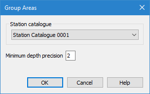
Option | Description |
|---|---|
Station catalogue | The station catalogue that was used to detect the shoals. When the shoals were detected, a specific station catalogue was used to determine reference depth and orientation. The same station catalogue must be used when regrouping the shoal areas. By default, the last selected station catalogue will be selected in the dialog box. The drop-down list is populated with all station catalogues in the currently open reference model. |
Minimum depth precision | The number of decimal places to include in the Minimum depth (shldep) attribute value of shoal boxes. The default value is 2. |
Procedure
1. Select the Shoal Areas layer in the Layers window.
2. Select the shoal areas in the Display window that you want to group.
This command will only enable if two or more shoal areas are selected, or if a single selected shoal area belongs to a shoal group that also contains other shoal areas. |
3. Select the Group Areas command.
4. Select a Station catalogue from the drop‑down list.
5. [Optional] Change the Minimum depth precision value.
6. Click OK.
The selected shoal areas are grouped and re-boxed. You can verify that the shoals have been grouped by re-selecting the shoal areas and viewing the Collection Feature ID value for each shoal in the Selection window. All shoal areas in a group will have the same value for this attribute.
