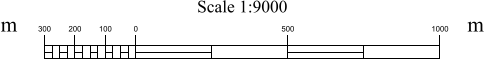
The scale bar is an integral part of any map or chart as it enables the reader to determine the relationship between distances on the map or chart and distances on the ground.
The scale bar is composed of the following elements:
• Caption (top and bottom)
• Major scale
• Minor scale
• Scale bar units text
Captions can contain any text that describes the scale bar or the chart.
The major scale is generally coarser than the minor scale and forms a larger part of the scale bar.
Both the major and minor scales are graduated using short and long ticks. The spacing of ticks on the major scale is independent of the spacing of ticks on the minor scale. The long and short tick spacing for either scale should be evenly divisible into the length of the scale. The short ticks are as long as the scale bar outline is wide. Long ticks are longer than short ticks.
The scale bar units text determines the units used for the distance labels of the scale bar and gives the actual text for labelling each end of the scale bar. Units are metric or imperial.
One distance label is placed over each long tick. These labels show the distance (metres or kilometres) covered by the scale bar on the ground.
Properties
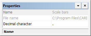
Property | Description |
|---|---|
Name | The name of the feature layer. Read-only. |
File name | The name and path of the file that contains the scale bars. Ready-only. |
Decimal Character | The character used to indicate decimal values. Type a character. |