The Compute GPS (Global Positioning System) Tide function provides an alternative to normal tidal observation for reducing soundings to the sounding datum
It is based on the recorded GPS ellipsoid height of the navigation antenna and uses the recorded vessel motion, if available, to reduce the ellipsoid height measurements to water level.
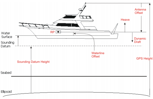
The formula for calculating GPS tide is:
GPS Tide = GPS Height - Datum Height + Antenna Offset - Heave + Dynamic Draft + Height Offset - Waterline Offset
The image below demonstrates the values in the GPS tide formula. The arrows indicate the positive sense of the values.
This diagram and equation show the formula for GPS tide where GPS Height needs to be motion corrected. However, in some systems, GPS Height may already be motion corrected. Applying sensor values (such as dynamic heave) again will only distort the final GPS Tide. The Compute GPS Tide command lets you include or omit selected sensor values.
See Compute GPS Tide