Menu | Tools > Surfaces > Combine |
Tool |
|
Menu | Tools > Surfaces > Combine |
Tool |
|
The Combine Surfaces command is used to combine multiple coverages into a new output coverage to be stored locally or on a database server. Coverages are combined when you have adjacent or overlapping surfaces that you wish to merge into one continuous surface. Overlapping areas are deconflicted with the application of user-defined rules.
There are two possible scenarios for combining surfaces:
• Multiple local coverages: Local coverages include raster surfaces and point clouds that are stored locally on your machine, and database surfaces that have been opened using the Open Surfaces from Database command. When combining local coverages, the selected coverages are combined into one new coverage with the data stored locally on your machine.
• Multiple database surfaces: Database surfaces include surfac objects stored in a database. When combining database surfaces, a new surfac object is created and the data stored in the database of the selected surfaces.
If using surfaces on a database, you must log in to the database before you can select objects from it. |
The location of each winning node in the output coverage depends on the source contributors of that node. The following conditions apply to each winning node:
If the contributor is... | The node location is... |
A point clouds | The true position of the point. |
A True Position raster | One of either the true position of the node, or the cell centre. |
A centre-of-cell raster | The centre of the cell. |
The Combine Surfaces command launches a wizard. In this wizard there are four steps to complete. Icons are displayed for each step to indicate whether the settings for that step will allow you to finish the process to create the new output surface.
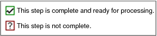
The process is ready to be finished once all steps have been completed.
Refer to the linked topics for information on each of the steps in the process.
