Menu | View > Change Coordinate Reference System |
Tool |
|
Status bar | [Coordinate reference system] |
Menu | View > Change Coordinate Reference System |
Tool |
|
Status bar | [Coordinate reference system] |
Select a coordinate reference system for the current data.
Coordinate reference systems represent an area of the globe on a flat surface. Projecting features of a spherical earth onto a flat map usually causes some or all of the features to be distorted. For example, the features may be stretched in one direction, or they may appear relatively larger than features in other areas of the map. Selecting a projection appropriate for the area being viewed helps to minimize the distortion.
Coordinate reference systems are based on entries in a file named mapdef.dat, located in the system folder. Its format is described in the top section of the file. This file refers to the ellipsoids defined in the datum.dat file in the same folder.
Related commands:
• Change Coordinate Reference System
Procedure
1. Select the Change Coordinate Reference System command.
The Select Coordinate Reference System dialog box is displayed.
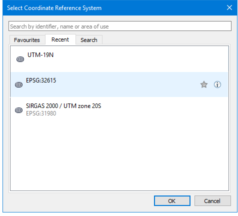
The Select Coordinate Reference System dialog box contains these tabs:
Tab | Displays |
Current | The coordinate reference system of the currently open data. |
Favourites | Any coordinate reference system that has been marked as a favourite. |
Recent | Recently used coordinate reference systems. |
Search Results | Coordinate reference systems that match the search criteria. |
To search for coordinate reference systems:
1. Type a string in the search box.
Strings are found if they appear in the identifier, the reference system name, or the area of use.
The search uses OR if you enter multiple words or phrases. You can use quotation marks to keep words together. For example, if you type zone 48, any system that has either zone or 48 in it will be found. If you type “zone 48”, only systems that contain that phrase will be found.
Press <ESC> to clear the search box.
Results are displayed in the Search Results tab.
When you click on or hover over a coordinate reference system, two icons are displayed:
Command | Icon | Description |
Favourite |
| Identify favourite or frequently used reference systems. 1. Locate the system you want. If this is the current or a recently-used system, you could find it in the appropriate tabs. Otherwise you can search for it. 2. Click on the Favourite icon. The icon turn yellow. The reference system will be displayed in the Favourites tab. Click the icon a second time to remove the system from the favourites. |
Info |
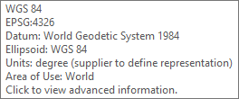
| Displays information about the system. 1. Locate the system you want. 2. Select it or hover over it. The Info icon becomes visible. If you hover over the icon, a tooltip displays information about the coordinate reference system. If you click on the icon, the advanced Coordinate Reference System dialog box is displayed. See Advanced Coordinate Reference System |
Advanced Coordinate Reference System
The Coordinate Reference System dialog box displays detailed information on the selected reference system, including names, major components, and values. This information is read-only and cannot be modified.
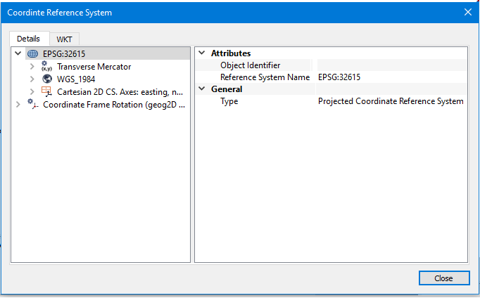
This dialog box contains these tabs:
Tab | Description |
Details | This dialog box displays detailed information on the selected reference system, including names, major components, and values. This information cannot be modified. The nodes of the coordinate reference system are displayed in the list on the left. 1. Click on a node. Node properties are displayed on the right. |
WKT | This tab displays the coordinate reference system as a WKT (Well Known Text) string. You can select and copy this string using the pop-up menu. |