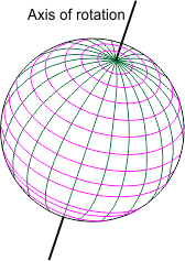
The axis of rotation provides a base for the geographic grid, a series of intersecting lines drawn on the globe for the purpose of fixing the location of surface features. It consists of a series of north-south lines connecting the poles (meridians of longitude) and a set of east-west lines running parallel to the equator (parallels of latitude).
A single meridian of longitude contains 180 degrees of arc that coincide with the north and south poles. Two opposite meridians of longitude cut through the centre of earth and represent a single great circle.
All meridians extend in a true north-south direction. They are spaced farthest apart at the equator and converge to common points at the poles. For any point drawn on the globe there exists a corresponding meridian of longitude.
The longitude of any location on earth may be defined as the arc measured in degrees along a parallel between that location and the prime meridian. The prime meridian is almost universally accepted as the one that passes through the Royal Observatory at Greenwich near London, England. It is also referred to as the Meridian of Greenwich and has an assigned value of 0 degrees. Meridians of longitude range from 0–180 degrees west and 0–180 degrees east from the prime meridian.
Parallels are always parallel to one another and maintain equal distances apart. They are true east-west lines that intersect meridians at right angles. All parallels of latitude are small circles except the equator. Any point on the earth lies on a parallel except the north and south pole, which occupy a point.
The latitude of any location on earth may be defined as the arc measured in degrees along a meridian between that location and the equator. Latitude values may therefore range from 0 degrees at the equator to 90 degrees north or south at the poles.