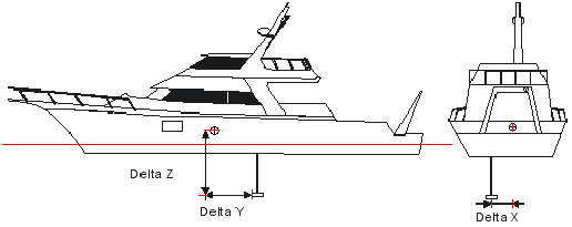
Vessel configuration is based on a three-dimensional coordinate system, which is used to record the location of sensors and other equipment, as illustrated below.
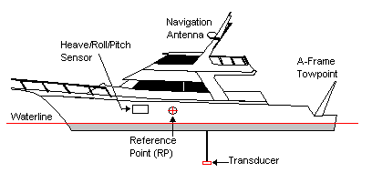
Reference point
Sensor positions are described using X‑Y‑Z axis coordinates relative to a reference point (RP). The RP is a location from which all other positions are derived.
The location of the RP depends upon the type of sonar system used in the survey. Its location is usually at the centre of gravity of the ship. This position is used as the centre of the ship’s rotation when applying the pitch/heave/roll parameters, and must be applied as accurately as possible.
Coordinate definitions
The axes are defined as follows:
• The Y-axis is oriented along the vessel’s fore/aft axis, positive forward.
• The X-axis is oriented along the vessel’s port/starboard axis, perpendicular to the Y-axis, positive to the starboard.
• The Z-axis is perpendicular to the X-Y plane, and positive into the water.
This is illustrated in the following image.
The location of the vessel’s coordinate system within the local fixed coordinate system is determined by the navigation system and tide. The orientation of the coordinate system is defined by the vessel’s gyro/heading and attitude sensors (pitch and roll). Gyro/heading, pitch and roll observations are defined as follows:
• A positive gyro/heading observation is defined as the clockwise rotation of the vessel (from 0 and 360 degrees) within the navigation coordinate system.
• A positive pitch is observed when the bow of the vessel is down (bow down).
• A positive roll is observed when the starboard side of the vessel is up (starboard up).