A reach is used to break a template into segments for the purpose of performing calculations, such as shoal detection. Reaches are usually referred to by the name of the feature that their reference model is based on.
The geometry of a reach is defined by the template alignment(s). The actual hydrographic information reported for a particular reach is obtained from numerous cross-sectional profiles of the waterway. These profiles are usually at stations, which are at given intervals (typically 200 feet) along the template alignment.
The reach itself can be divided into segments of the template width by creating partitions in that reach. A partition is a function of a profile and its bounding template used to divide the length of a profile into segments. The partitioning rules also allow for a tolerance factor, which is the percentage of distance (inward from the template limits) ignored during calculations.
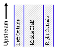
Up to twenty partitions can be created in each reach and each partition is named according to the number of partitions created. For example, if the division results in three partitions, they would be named: “Middle Half”, “Left Outside”, and “Right Outside”.
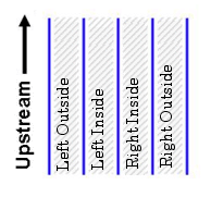
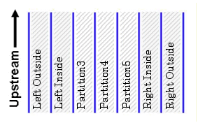
The left-side partitions are always on the side of the reach that is going upstream. |
If there were four partitions, they would be named: “Left Outside”, “Left Inside”, “Right Inside”, and “Right Outside”.
If there were five partitions, they would be named: “Left Outside”, “Left Inside”, “Middle”, “Right Inside”, and “Right Outside”.
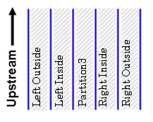
If there are more than five partitions, each additional partition is added between “Left Inside” and “Right Inside”. They are labelled Partition3 to Partition16 appropriately.
See New Station Catalogues for information on creating reaches.