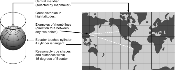
General | Used for navigation or for maps of equatorial regions. Any straight line on the map is a rhumb line (a line of constant direction). The equator and other parallels are straight lines whose spacing increases toward the poles and which meet meridians at right angles. Meridians are equally spaced straight lines. The poles are not displayed. A Mercator map is conformal, but it is not perspective, equal area, or equidistant. |
Directions | Directions along a rhumb line are true between any two points on the map, however, a rhumb line is usually not the shortest distance between points. |
Distances | True only along the equator. Reasonably correct within 15 degrees of the equator. |
Scale | Special scales can be used to measure distances along other parallels. Two particular parallels can be made correct in scale instead of the equator. Sometimes used in conjunction with a Gnomonic map where any straight line is on a great circle and shows the shortest path between two points. |
Areas | Distorted. Distortion increases with distance from the equator and is extreme in polar regions. |
Shapes | Shapes of large areas are distorted. Distortion increases with distance from the equator and is extreme in polar regions. Angles and shapes in any small area are essentially true, |
Type | Cylindrical. Mathematically projected onto a cylinder tangent to the equator. The cylinder may be secant |
History | Presented by Gerardus Mercator in 1569. |
| |
Note | Directly supported. |
(United States Geological Survey, n.d.) | |