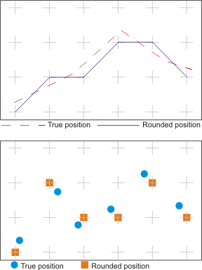
The resolution of the data is the smallest possible distance that can be measured between two points. Two points which are separated by a distance less than the resolution are considered to be coincident.
For example, if the resolution of your data is one metre at ground scale, two points less than a metre apart cannot be distinguished. The location of points will be rounded to the nearest metre.
The level of accuracy of data varies according to the way data is collected. The coordinate accuracy of data taken directly from a stereoplotter is generally higher than that taken from a paper map, assuming that the scales are similar; a list of surveyed coordinates is likely to be the most accurate of all.
The requirements for accuracy vary with circumstances and almost always require compromise. In certain applications, the requirements for accuracy must be tempered by the nature of the physical conditions. For example, natural features such as soil types, forest species, or climatic regions do not have sharply defined limits. The transition from one type to another tends to be gradual. Boundaries are only approximate at best. Collecting boundary data at sub metre accuracy is not warranted.
However, boundaries imposed by humans can be presented at a higher level of accuracy. In some instances, such as legal property boundaries, this high level of accuracy is required.
Requirements for accuracy may also be tempered by the requirements of another agency that uses the data you collect.
Future use of the data also tempers accuracy requirements. If more accurate data will be available in the future, collect the present data to that accuracy. This allows for future capture of more accurate data without reconstructing existing files.
If the cartographic appearance is important, a fine resolution may be required to retain the smooth appearance of a line. A coarse resolution will result in jagged lines on a plot. Too fine a resolution, however, can result in jagged lines, showing the shakiness of the digitizing operator’s hand.
The recommended rule of thumb for choosing a resolution is to capture all data at the highest level of accuracy available to you. |