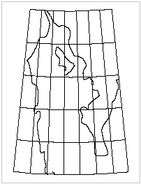
A graticule is a geographic grid that corresponds to parallels of latitude and meridians of longitude. Graticules can be curved, depending on the projection and the geographic area covered.
The graticule spacing must be specified so it aligns consistently with any ticks that are displayed. For example, if half ticks have a 15-minute spacing, and full ticks have a 1‑degree spacing, a graticule spacing of 30 minutes is acceptable since it will align with every full tick and with the half ticks that lie midway between the full ticks. A graticule spacing of 40 minutes, on the other hand, produces an unacceptable result.
Graticules can be displayed as full lines, as crosses at intersections, or both.
Properties
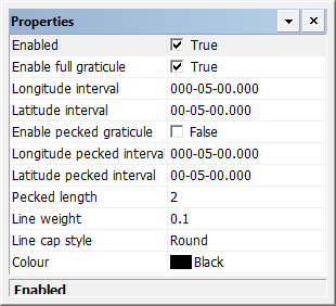
Property | Description |
|---|---|
Enabled | True: Display graticule lines. False: Do not display graticule lines. |
Enable full graticule | True: Display the graticule as full lines. False: Do not display the graticule as full lines. Unless Enable pecked graticule is True, no graticules will be displayed. |
Longitude interval | Interval between graticule longitude lines. Type a value. |
Latitude interval | Interval between graticule latitude lines. Type a value. |
Enable pecked graticule | True: Display the graticule as crosses at the interval of latitude and longitude lines. False: Do not display crosses. |
Longitude pecked interval | The interval between pecked graticule longitude lines. Type a value. |
Latitude pecked interval | The interval between pecked graticule latitude lines. Type a value. |
Pecked length | The length of the arms of the crosses in millimetres at map scale. Type a value. |
Line weight | The thickness of the graticule lines in millimetres at map scale. Type a value. |
Line cap style | The end style of the lines. Styles are butt, projected, and round. Select from the list. |
Colour | The colour of the graticule lines. Click the button and choose a colour from the colour picker. |