Option | Description |
|---|---|
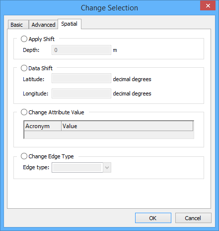
Apply Shift | Apply depth shifts to soundings. 1. Enable Apply Shift. 2. Type the shift in metres in the Depth field. The shift value can be negative or positive. |
Data Shift | Shift selected features by latitude or longitude. Units are decimal degrees. Warning: Shifting features that share geometry with other features could adversely affect your data. The extent of the change is determined by the Shared Edit command: • On: Changes are applied to the selected features and to the edges of features that share geometry with them. • Off: Changes are applied only to the selected features. A message will be displayed to tell you which features will be affected. See also Shared Edit. 1. Enable Data Shift. 2. Type shift values in decimal degrees. |
Change Attribute Value | Change values for POSACC and QUAPOS spatial attributes. The extent of the change is determined by the Shared Edit command: • On: Changes are applied to the selected features and to the edges of features that share geometry with them. • Off: Changes are applied only to the selected features. A message will be displayed to tell you which features will be affected. See also Shared Edit. 1. Enable Change Attribute Values. 2. Select an attribute from the Acronym column. 3. Set the value, Depending on the attribute, you either type a value or select on from the list. |
Change Edge Type | The extent of the change is determined by the Shared Edit command: • On: Changes are applied to the selected features and to the edges of features that share geometry with them. • Off: Changes are applied only to the selected features. A message will be displayed to tell you which features will be affected. See also Shared Edit. 1. Enable Change Edge Type. 2. Select from the list: • Edge: Convert a geodesic line or loxodrome to an edge. • Geodesic: Convert an edge or a loxodrome to geodesic. • Loxodrome: Convert an edge or a geodesic line to a loxodrome. |