Menu | Tools > Measure Distance and Angle |
Tool |
|
Menu | Tools > Measure Distance and Angle |
Tool |
|
Measure the distance and angle between points in the Display window or the 3D View.
This tool can also be used in the Profile window and the 2D and 3D Subset Views of the Subset Editor when certain licensed modules are enabled. The tool can only be active in one window at a time. Switching between windows will cancel the active measurement.
The distance and angle units shown for the measurements are derived from the Units settings in Tools > Options. You can select Geodetic or Projected distances using the Measurements Reference option. See Options.
Measurements will be displayed as “ |
While measuring:
• To snap to a feature, press <S> before clicking on the point.
• To remove the last point, press <Backspace>.
• To cancel the current measurement, press <Enter>, <End> or <Esc>, or right-click and select Distance > Cancel. This ends the current measurement and clears the Coordinates window, but leaves the command active.
• To exit the tool, press <Esc> a second time or right-click and select Distance > Quit. This exits from the command.
In a 3D view, each point is automatically snapped to an existing node or other 3D location.
Procedure
1. Select the Measure Distance and Angle command.
The cursor changes (  ).
).
2. Click at the starting position.
3. Click at any other necessary points.
As you click, control points are added to the display and the measurements between the last point and the cursor are displayed in the Coordinates window. The starting point is represented by a larger square, and the current point is represented by a red square.
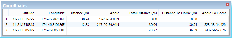
In 2D view, the following columns are displayed in the Coordinates window:
Column | Description |
Latitude/X | Latitude or X location of the point. |
Longitude/Y | Longitude or Y location of the point. |
Distance | The distance between the current point and the previous point. |
Angle | The angle between the current point and the previous point. |
Total Distance | The cumulative distance of the entire measurement line up to the current point. |
Distance to Home | The distance between the current point and the start point in a direct line. |
Angle to Home | The angle between the current point and the start point in a direct line. |
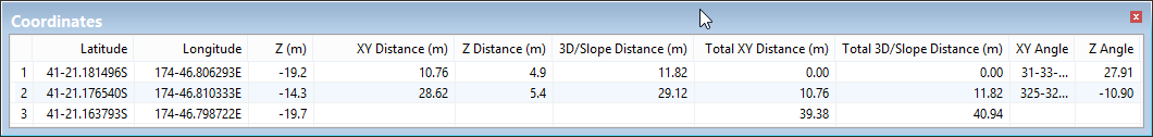
In 3D view, the following columns are displayed in the Coordinates window:
Column | Description |
Latitude/X | Latitude or X location of the point. |
Longitude/Y | Longitude or Y location of the point. |
Z | The elevation of the point |
XY Distance | The distance between the current point and the previous point, ignoring any elevation differences. |
Z Distance | The elevation distance between the current point and the previous point. A positive value means the second point has a higher elevation. |
3D/Slope Distance | The Euclidean 3D distance along the slope between the current point and the previous point. |
Total XY Distance | The cumulative distance from the starting point to the current point, following the line, and disregarding all elevation information. |
Total 3D/Slope Distance | The cumulative Euclidean 3D distance along the slopes between each successive point, from the starting point to the current point. |
XY Angle | The angle from the current point to the previous point, disregarding all elevation information. |
Z Angle | The slope of the line from the current point to the previous point, measured in degrees. |
