For description of how ZDF file are used, see: Tide Zone Files in the HIPS and SIPS Reference Guide
To apply tide, see:
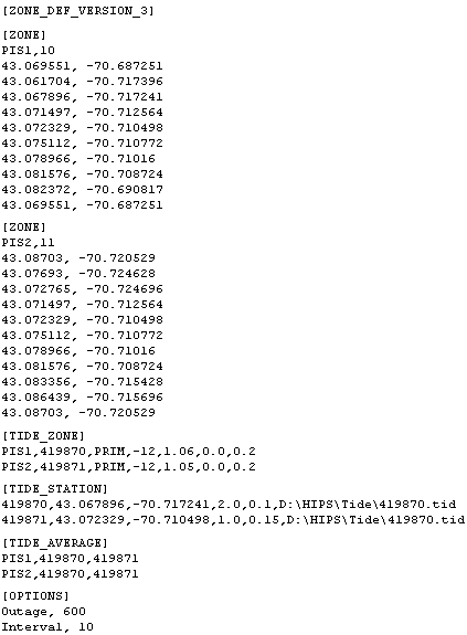
The following is an example of a Zone Definition File (.zdf).
Tide Zone Data
The Zone Definition File has the following components:
• The mandatory header section must consist of this text string: [ZONE_DEF_VERSION_3]. This specifies the version of the Zone Definition File.
• The section labelled [ZONE] contains the name of the zone(s) and the coordinates that define the boundary of the zone(s). All tide zone files must contain this section.
There are two fields in the first line:
• <Zone Label> contains name of the zone (the name must not be longer than 256 characters).
• number of points that define the boundary of the zone. (These are listed starting in the next line of the section.)
The remaining lines in this section list the geographic coordinates of these points, (latitude, longitude) in decimal degrees.
The last line in the list must contain the same coordinates as the first line to close the polygon.
If there is more than one zone being defined, this section is repeated with the definition information for each zone.
Tide zones should not overlap each other. |
• The section labelled [TIDE_STATION] contains the definition of the tide stations collecting the tide observations. There are six fields in each record of this section:
• station label (the name of the tidal station) - The name must not be longer than 256 characters.
• latitude in decimal degrees - Valid ranges are from -90.0 to +90.0. The negative range represents the Southern Hemisphere.
• longitude in decimal degrees - Valid ranges are from -180.0 to +180.0. The negative range represents the Western Hemisphere.
• max amplitude (in metres) expected from the tidal station - This value will be used to compute a scaling factor during the Tidal TPU computation.
• uncertainty error value associated with the data from the station (in metres)
• [optional] full file path and name, or just the name of the tide file associated with the station ID. If this is omitted, HIPS will look for an observation file in the same directory as the *.zdf, with the file name <Station_Label>.tid.
• The section labelled [TIDE_ZONE] contains specific attributes that define a zone’s tidal parameters. There are seven fields in this section:
• tide zone label - this must match the name of the zone(s) defined in the [ZONE] section.
• tide station label - name of the tidal station associated with this entry.
• priority designation of the tidal station entry: either the primary (PRIM), secondary (SEC), tertiary (TER) or preliminary (PRELIM) station for this zone.
• time correction - the tide offset for this zone (in minutes) (This is not used when tide is loaded with the weighted average option enabled.)
• range correction - a multiplier (for example, 1.06) used to scale the tidal value read from the observation file (This is not used when tide is loaded with the weighted average option enabled.)
• tidal shift - a number in metres added to the values after range correction has been applied.
• uncertainty value for the tidal zone (in metres) used to compute the Tidal Zone Error.
• The section labelled [TIDE_AVERAGE] assigns tide stations to zones for tide-weighted averaging. Each record has at least two station fields because each zone can be assigned one or more tide stations for the weighted average calculation.
The section has the following fields:
• tide zone label - the zone (as defined in the [ZONE] section) to which the averaging should be applied
• tide station label, (as defined in the [TIDE_STATION] section). Enter as many as needed for averaging.
• The last section labelled [OPTIONS] contains options used during tide zoning or tide averaging.
• The limit value field contains the outage time in minutes before switching from the current station to the next priority station
• final interval in seconds of tide data loaded into the track line.