Menu | Tools > Engineering Analysis > Shoals > Detect Shoals |
Tool |
|
Menu | Tools > Engineering Analysis > Shoals > Detect Shoals |
Tool |
|
The Detect Shoals command is used to identify shoals in the currently selected surface. A shoal is an area where sedimentation and/or deposited objects cause bathymetry to no longer conform to the expected reference model. This excess material is a hazard and must be addressed to allow normal usage of the waterway. In the mean time, however, mariners must be informed about these exceptions to the model.
Shoals should only be detected on bathymetry with true depths. You should not detect shoals on a difference surface or other files that do not contain true depths.
Detected shoals are saved to a pair of files:
• A HOB map file (.shl) containing the shoal data
• A CSAR file (.csar) containing the bathymetry around the shoal areas as it was at the time of detection
The .shl file can be opened at any time using the Open command.
The shoal boxes are created parallel to the alignment in the station catalogue based on the shoal areas grouping and the splitting interval. There can be multiple area groups in a single survey. The groups can be changed manually if necessary. See Group Areas for more information.
Related commands:
Interface
The Detect Shoals command uses the following dialog box.
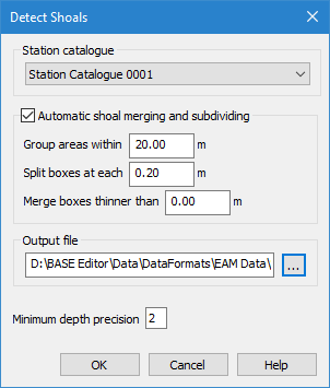
Option | Description |
Station catalogue | You must select a station catalogue in order to associate the shoals with the current reference model. The station catalogue contains: • the alignment that is used to determine shoal orientation, • the template that is used to determine the reference depth and shoal clearances, • the reach that is used to identify the area in which the shoal was found, and • the partitions used to determine shoal severity classifications. This selection will be remembered in other shoal-related dialog boxes used in future procedures. Only station catalogues with a single alignment-template pairing are available to be selected in this dialog box. |
Automatic shoal merging and subdividing | During detection you can have shoals automatically grouped, split and/or merged based on the size and location of each shoal. Select this option to turn on automatic merging and subdividing. |
Group areas within | Grouping causes shoal areas to be assigned to the same group of boxes if the areas are within a user-specified distance of each other. 1. Enter a distance value in the text-entry box. |
Split boxes at each | Splitting causes shoal areas to be created at each multiple of a user-specified interval value. This allows the shoal areas that are more critical to be displayed separately from the areas that are less shallow. 1. Enter an interval value in the text-entry box. |
Merge boxes thinner than | Merging causes shoal boxes to be combined if they are smaller than a specified value. 1. Enter a size value in the text-entry box. |
Output file | The name and location for the resulting shoal layers and files. Click the browse button (...) to launch a standard Windows Save dialog box and define a name and location. |
Minimum depth precision | The number of decimal places to include in the Minimum depth value of shoal boxes. The default value is 2. |
Procedure
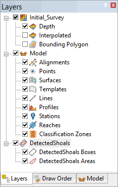
1. In the Layers window, select a layer with depth values from the surface for which you want to identify shoals.
2. Select the Detect Shoals command.
The Detect Shoals dialog box is displayed.
3. Select a Station catalogue from the list.
4. Select any other necessary options.
5. Define a name and location for the shoal layers and files.
6. Click OK.
The shoals are detected and saved. Layers are added to the Layers window for each of the shoal feature types.