General | Can be used to map large continent-sized areas of similar extent in all directions, such as the Arctic and Antarctic. Used in geophysics to solve spherical geometry problems. Polar aspects are used for topographic maps and navigation charts for latitudes above 80°. Conformal and perspective but not equal area or equidistant. |
Directions | True only from the centre point of projection. |
Scale | Increases away from the centre point. Any straight line through the centre point is a great circle. |
Areas | Distortion increases away from the centre point |
Shapes | Distortion of large shapes increases away from the centre point |
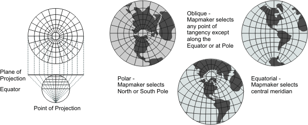
Type | Azimuthal. Geometrically projected on a plane. The point of projection is at the surface of the globe opposite the point of tangency. |
History | Dates from the second century BC and is ascribed to the Greek astronomer Hipparchus. |
| |
Note | Directly supported. |
(United States Geological Survey, n.d.) | |