Menu | Process > Compute Separation Model |
Generate a separation model based on traditional tide inputs as well as other vessel dynamics. The model is saved in a CSAR format and opened as a background layer. The layers making up the model will be displayed in the Layers window, and a CSAR file will be created in the output folder.
A separation model will be created using all of the data in the project, or only the selected data if “Selection” is set in the Input Source field.
Interface
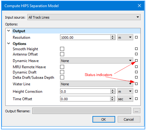
The Compute Separation dialog box is used to set create the separation model.
The fields in the dialog box are set to default values. If a setting is changed from the default, the status indicator box for the field changes to grey. Defaults can be restored by clicking on the indicator box and selecting “Reset”.
Options
Option | Function |
Input Source | If a track line or lines was selected, you have the option to chose Selection, or All Track Lines from the drop-down list. |
Resolution | 1. Set a resolution value in the Resolution field. 2. Select the unit of resolution from the drop-down list. The default setting is metres. |
Smooth Height | 1. Select the check box to apply smoothing to GPS height. |
Antenna Offset | 1. Select the check box to apply the offset of the GPS antenna from the reference point. |
Dynamic Heave | 1. Select heave or delayed heave, if available. Default setting (None) means no heave is applied. |
MRU Remote Heave | 1. Select the check box to apply remote heave resulting from vessel roll/pitch on an offset-mounted MRU. |
Dynamic Draft | 1. Select the check box to apply dynamic draft (as a result of interpolating the draft table in the HIPS Vessel File (HVF), or as stored in HIPS as time series data). |
Delta Draft / Subsea Depth (vehicle depth) | By default, Dynamic Draft (if available) is always applied if the option is set in the HIPS Vessel file. If the Delta Draft option check box is selected, Delta Draft (if available) is applied in addition to Dynamic Draft rather than being applied instead. 1. Select the Delta Draft / Subsea Draft check box to apply available Delta draft data. |
Water Line | 1. Select Vessel or Realtime to apply the waterline offset in the HVF. Default is None. |
Height Correction | 1. Type an amount to use as a static offset to the GPS antenna. 2. Select the unit of measure from the drop-down list. The default setting is metres. |
Time offset | 1. Type a value to apply as a time offset. 2. Select the unit of measure for the resolution from the drop-down list. The default setting is seconds. |
Output file name | 1. Click Browse to set or select an output file. |
Procedure:
1. Open a project containing Tide and GPS Height data.
2. Activate the Ship Track Lines layer in the Layers window.
3. [Optional] Select a line or lines of data to compute the model only for data in those lines.
4. Select the Compute Separation Model command.
In the Compute Separation Model dialog box:
5. Set appropriate Options to apply them in the model.
6. Click OK.