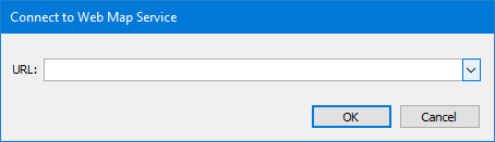
Menu | File > Open URL > [service name] |
Open data available via web services.
Supported services are:
Service | Description |
Enhanced Compression Wavelet | Using the Enhanced Compression Wavelet (ECW) protocol allows you to view ECW and JPG2000 raster images available from a server. |
Onboard Service | The CARIS Onboard™ service allows you to view a product, such as a mosaic or gridded surface, as it is updated in real time during data processing. See Onboard Service for more information. |
Tile Map Service | A Tile Map Service (TMS) returns raster images from a tile-based portrayal service for geospatial data. TMS is similar to a WMTS, but with different standard protocols. The default tile size is 256 x 256 pixels. A well-known provider of a TMS is OpenStreetMap but users should be aware of their Tile Usage Policy before using this service. Information can be found at: http://wiki.openstreetmap.org/wiki/Tile_usage_policy |
Web Coverage Service | A Web Coverage Service (WCS) opens coverages from a server. A WCS is an Open Web Service (OWS), and coverages are geospatial representations of map data retrieved as rasters. These rasters may be images or they may contain depth information. See OGC Web Services for more information. |
Web Map Service | A Web Map Service (WMS) returns raster images. A WMS is an Open Web Service (OWS) that is a portrayal service for geospatial data. See OGC Web Services for more information. |
Web Map Tile Service | A Web Map Tile Service (WMTS) returns raster images. A WMTS is a tile-based portrayal service for geospatial data. Tiles are retrieved at a resolution based on the current view scale in Teledyne CARIS applications, similar to CSAR data. Tiles will be retrieved in their entirety, regardless of the current view extents. See OGC Web Services for more information. |
If you use a proxy server to access your network or browser, you may need to define connection settings. See Options and contact your system administrator for assistance.
Some services provide different sources in different versions, but not all versions are supported in Teledyne CARIS applications. The following service versions are supported:
• WMS 1.0.0, 1.1.0, 1.3.0
• WMTS 1.0.0
• WCS 1.0.0, 1.1.0, 1.1.1
Contact Teledyne CARIS Customer Service if you have issues with the version used by the server that you are accessing.
Procedure
1. Select the command for the desired service.
The dialog box for the selected service is displayed.
Option | Description |
URL | The address of the service to which you want to connect. Each time an address is entered and run, it will be saved in the list for future use. Each service can remember up to 10 addresses. To remove a saved address, right-click the address in the list and choose Delete. |
2. Either:
• type a valid address, or
• select a previously used address from the list.
3. Click OK.
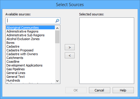
Sources
For the WMS, WMTS, WCS and Onboard service types, the Select Sources dialog box is displayed if more than one data source is available.
Option | Description |
Available Sources | A list of all available sources. To search for a source, type in the search box and click the search tool. To select a source, highlight it and click >. The source is moved to the Selected sources list. |
Selected Sources | A list of all selected sources. Only sources in this list are opened. To deselect a source, highlight it and click <. The source is moved to the Available sources list. |
If only one source is available, this step is skipped.
4. Choose one or more sources.
Each source from a service can have unique data extents.
• If data was open before connecting to the service, the service will display only data within the extents of the current view.
• If no data was open, the selected source will be displayed using the full extents available for that source. For a TMS service, this means the full world map.
All data provided for a service can be accessed by changing the view using the Zoom, Pan and Overview commands. The data is updated dynamically any time the view is changed or refreshed.
For the other service types, data will be returned for the view extents specific to the URL entered.
If you experience problems displaying data from a service, you may need to select an appropriate coordinate reference system for the service layer. See Change Coordinate Reference System for more information. |
5. [Optional] Type an entry in the Search field to filter the list of sources.
6. In Available Sources, select a layer list that you want to open and click the right-arrow button.
The layer is moved to the Selected Sources list.
7. Repeat for each source you want to open.
8. Click OK.
The selected data is opened.
Some sources are opened as raster images. The format of the image is the first available format that is supported in Teledyne CARIS applications. Certain services attempt to use specific formats. For example, WCS will attempt to retrieve a GeoTIFF if GeoTIFFs are available from the server. If this format is not available, it will look for PNG, then others. WMS will return a PNG image if possible.
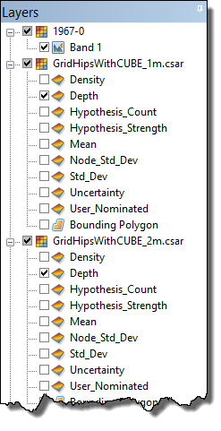
If you chose to open multiple sources from a service at once, the images are automatically grouped in the Layers window with the group layer named according to the service being used.
WMS, WMTS and WCS data will be opened in the first coordinate reference system that is supported in Teledyne CARIS applications. TMS is always opened in EPSG:3857 (Google Mercator). The coordinate reference system of each source will be used, and they will be re-projected on the fly.
Layer Tree
If you selected more than one source, each source will be displayed in the layer tree. You can select the layer or layers of interest and refresh the screen to see the desired data.