Menu | Model > New Model |
Tool |
|
The New Model command is used to create a new reference model in a new file (XML format).
A reference model is comprised of reference model features (some of which are described in Reference Model Features,) and metadata. This metadata includes:
• Name: a unique name that identifies the reference model;
• Coordinate system: the coordinate system used to store the reference model feature positions (X, Y);
• Units: the vertical and horizontal units of measure selected for the X, Y, and Z values of the features; and,
• Resolution: the resolution used to store the X, Y, and Z values of the features.
New features in a reference model have a default name (prefix) and a sequential number so that each feature has a unique identifier.
These names can be edited later, using the Model Feature window, if necessary. |
To create a new reference model:
1. Select the New Model command.
Menu | Model > New Model |
Tool |
|
The New Reference Model dialog box is displayed.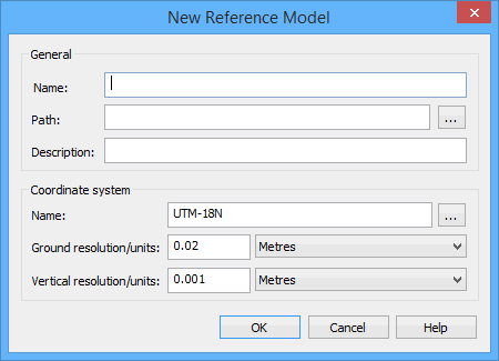
Reference model names can contain alphanumeric characters, spaces, extended characters and most symbol characters.
2. In General, type a Name for the reference model.
3. Click the Path Browse (...) button and select the a location for the new reference model.
The Browse For Folder dialog box is displayed.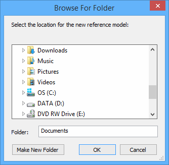
You can choose a folder by performing one of the following actions:
• Browse to the location of the file in the data tree.
• Copy the full path for the file into your clipboard and paste the path into the Folder field.
• Type the full path for the file in the Folder field.
4. Choose a folder in which to store the reference model.
If desired, a new folder can be created using the Make New Folder button. Select the new folder, type a name, and press <Enter>. |
5. Click OK.
The dialog box closes and the New Reference Model dialog box is redrawn; the path you selected is displayed in the Path field.
6. [Optional] Type a Description for the reference model.
Next, you must specify the coordinate system and units of measure to use.
7. To select a projection different from the one displayed in the Coordinate System Name field, click the Browse (...) button.
The Select Coordinate Reference System dialog box is displayed.
8. Select a coordinate system to use for the reference model and click OK.
Reference models do not support Geographic (Lat/Long) coordinate systems because they do not guarantee precise calculations. |
The Select Projection dialog box is closed and the New Reference Model dialog box is displayed. Your selection is displayed in the Coordinate system Name field.
For each of the drop-down lists (Ground, Vertical), a resolution value must be entered and a unit of measure selected. The resolution values default to the smallest possible values when the step is displayed.
The smallest possible value for Ground resolution is 0.02m; the smallest possible value for Vertical resolution is 0.001m. |
You can import reference models with resolution values higher than the defaults, however, imported points that are separated by a distance greater than the resolution will be "skipped". Any features relying on skipped points will be incomplete, and must be corrected manually.
9. From the Ground units drop-down list, select a unit of measure option.
10. [Optional] Edit the default value for Ground resolution.
11. From the Vertical units drop-down list, select a unit of measure option.
12. [Optional] Edit the default value for Vertical resolution.
13. Click Finish to create the reference model.
If the reference model name you specified already exists in the selected location, the following message will be displayed when you click Finish.

If the overwrite message is displayed,
• Click Yes to overwrite the existing reference model, or
• Click No to change the name or location of the new reference model. You will be returned to the New Reference Model dialog box to enter a new name/path and click Finish again.
If a "Could not create the reference model." error message is displayed after you click Finish, close the message, try replacing any symbol characters in Name with letter, number, or space characters, and click Finish again. |
The new model is created and opened. If no other reference model is open, it will be set as the active model. See Set as Active Model for more information on defining the active model. The metadata of the reference model is defined and the view extents are setup to begin the creation of the model features.
