![]() Product Editor
Product Editor
![]() Source Editor
Source Editor
Menu | Tools > Coverages > TIN > Digitize Point |
Tool |
|
This command is only available if the Bathymetry Compilation module is enabled. See Modules for further information |
Add a new point to a TIN.
The points in a TIN represent depths and elevations. The triangles in the TIN connect these points. The more points you have, the more accurate your TIN representation will be.
Depending on the level of detail required for a particular task, a new point might be needed if there are multiple variations in elevation in a particular area, but only a few surface points.
Procedure
1. Make TIN Editor layer active and visible.
2. Select the Digitize Point in TIN command.
The Tool Depth dialog box is displayed.
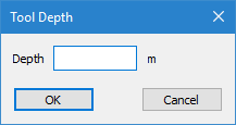
3. Enter the depth for the point.
4. Click OK.
The cursor changes. You can now digitize the point.
5. Click at the location of the new point.
6. Repeat as necessary.
The points are digitized, but they are not yet save or applied to the TIN.
Use the Update TIN command to apply the new points to the TIN.
The edges in the TIN are updated based on the new point.