![]() CARIS HPD Paper Chart Editor
CARIS HPD Paper Chart Editor
![]() CARIS Paper Chart Composer
CARIS Paper Chart Composer
Menu | File > Export > Sheet > PDF |
Export a sheet to a geospatial PDF file.
A specific area can be exported by using the Export Area command.
Related commands:
• • • • • | • • • • • |
Interface
Properties | Description |
|---|---|
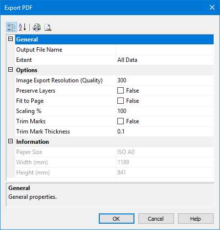
Output File Name | The name of the exported PDF file. 1. Click Browse to open the Save As dialog box. 2. Select a path and type a name for the file. 3. Click Save. The path and name are listed in the dialog box. |
Extent | The area that is to be exported. Select from: • All Data to export the entire sheet. • Current View to export the area of that is currently displayed. • Export Area to set an area of the panel for export. |
Image Export Resolution | The DPI size for images that are exported with the sheet. Type a value in the field. |
Preserve Layers | Export a chart to a PDF file that retains the same layer structure as in the application. Note: This option exports vector layers without dynamic masking. Turn off raster layers or dynamically masked layers. Click the check box to change the value from False to True. |
Fit to Page | Fit the chart to an entire page. Select the check box to fit the sheet to the page |
Scaling | Set the chart to a percentage of its original size. This option is available if the Fit to Page option is not selected. Type a percentage in the field. |
Trim Marks | Add trim marks to a sheet as guides to trimming oversized sheets. Click the check box to change the value from False to True. |
Trim Mark Thickness | Thickness of trim marks in millimetres. Type a value. |
Procedure
1. From the Layers window, select the Sheet layer.
2. Select the Export Sheet to PDF command.
The Export PDF dialog box is displayed.
3. Define any necessary properties and click OK.