Bathy DataBASE Server 5.1
This section describes all changes made to the application in the 5.1 series of releases.
5.1.1
July 2018
Maintenance
BASE Manager
Reference | Description |
|---|---|
Coverages | |
01800300 | Coverages with designated soundings that were vertically shifted, using either the Vertical Shift command or the Shift Elevation Bands process in CARIS Batch, can now be uploaded into the database, including through the Set Coverage command. |
Supported data referencing the Google Mercator coordinate reference system (CRS), referring to the projection as Mercator_Auxiliary_Sphere, can now be uploaded to the database. | |
Changes were made to support faster reading/writing of CSAR raster surfaces. No functional changes are expected. | |
Python API | |
The appearance of the Python API documentation has been updated. | |
5.1.0
May 2018
Highlights
☼ New scope for BDBTM Server
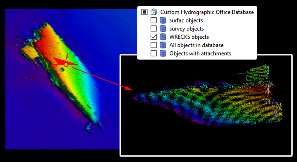
As part of expanding the scope of activities that can be supported in CARIS1 Bathy DataBASE2 ServerTM, databases now supports both feature and coverage data management. The object and attribute model is now fully exposed to the user and can be customized to include any point, line or polygon feature types as required by the customer. This allows the role of BDB Server within an organization to expand beyond the management of bathymetric DEMs and into new areas of data management for features (such as for Wrecks or administrative boundaries) and coverages (such as backscatter mosaics or Lidar point clouds). New feature portrayal options allow for styling that can be tailored for use of the system in different domains such as charting, oil and gas exploration and port and waterway management.
☼ Expanded Python API
A new Python module has been added to support interacting with vector data in a wide variety of formats New capability has also been added to the coverage and BDB Server modules, to allow scripting a wider variety of workflows, with goals of simplicity, usability, and versatility.
For example, a Python script can now be used to automatically populate vector feature attributes whenever a feature is created, or when a feature is edited, or when an associated coverage is uploaded to the database. A very simple example is to automatically populate the Recording date attribute when a feature is created, which can be accomplished with just a few lines of code.
import datetime | def feature_created(newFeature): | newFeature.attributes['RECDAT'] = datetime.datetime.now().strftime("%Y%m%d") |
General Notices
• A new license string is required for Bathy DataBASE Server 5.x. Contact CARIS Customer Services for more information.
• Installations are now only provided as full installations. Patch installations with roll-back capability are no longer supported.
• Minor versions of BDB Server will now upgrade previous versions. For example, installing BDB Server 5.1.0 will remove 5.0.0.
• BASE EditorTM 4.x cannot connect to BDB Server 5.x. Only BE 5.0.0 and later is expected to have compatibility with BDB Server 5.x.
• The scripts to upgrade from older versions to BDB Server 4.2 have been removed. If using a BDB Server application older than 4.2, it is necessary to first upgrade to 4.2 before upgrading to 5.x.
• User permission strategies have changed; database security is now handled by the RDBMS. As part of this change, each user is now assigned a single role for all databases managed by a given Node Manager Service. When updating a database from a previous version of BDB Server, user permissions are automatically upgraded so each user now has the maximum permissions they had previously been assigned on any of the updated databases. Do not upgrade if you need database‑specific access permissions for users.
• It is recommended that existing attribute mapping files be downloaded prior to upgrading to BDB Server 5.0 and used to create new Python attribute mapping scripts, if relevant, as the upgrade procedure will remove the attribute mappings.
• The most recent releases of Spatial Fusion Enterprise (SFE Server 7 and SFE Runtime 15) do not support BDB Server 5.x. Do not upgrade if you rely on SFE to web-enable your coverage data stored in CARIS Bathy DataBASE Server.
• ServerAddToRasterCombine will only work on raster surfaces created by the ServerCombineToRaster process in 5.0.0 or later.
Maintenance
Administration Tools
Reference | Description |
|---|---|
Installations | |
Two different minor versions of the application are no longer supported on the same system at the same time. Installing a newer minor version now automatically replaces any older versions currently installed on the computer. For example, installing BDB Server 5.1.x automatically uninstalls BDB Server 5.0.x. | |
The installation wizard now automatically suggests the location of the last relevant BDB Server installation as the default location for the new installation. For example, if BDB Server 5.1.0 is installed in a custom location, BDB Server 5.1.1 automatically proposes the same custom location. | |
Logging | |
Error logging has been improved for user authentication issues. | |
User Management | |
01800749 | When using an Oracle 12 RDBMS, the User Management tab of the BDB Server Administration Tools now shows all users, even when there are more than 32 users. |
Cloning a database can now be done by all users with administrator privileges, not only those with DBA roles. | |
BASE Manager
Reference | Description |
|---|---|
Catalogues | |
The new sample BDB Server database catalogues have been updated to all have unique IDs to allow switching between the catalogues. | |
The new sample BDB Server database catalogues have been updated to define date attributes as dates, instead of generic strings. BDB Server still stores date attributes in the RDBMS as strings. | |
Coverage Tools | |
01800570 | The Server Combine to Raster process was failing to update nodes with designated soundings from the winning source when applying dataset metadata based on bounding polygons. This has been fixed. |
Database Objects | |
The sample feature plugin scripts have been updated to only try to set attribute values if the feature has the specified attribute. | |
The sample feature plugins for the new sample BDB Server database catalogues now populate the identification dates/RECDAT attributes in CCCCMMDD format instead of CCCC-MM-DD. | |
Vertical coordinate reference system information is now included in the CoverageCRS attribute for database features with an associated coverage. | |
1 This term is a trademark of Teledyne CARIS,Inc. Reg. USPTO and CIPO.
2 This term is a trademark of Teledyne CARIS,Inc. Reg. USPTO.